Thursday, September 25, 2008

University Heights


Moving eastward from Funston back towards Durham and before I launch a longer series on Hickstown I thought I'd pause briefly at University Heights with some cautionary notes about maps. I recently came across plats of the great neighborhood of "University Heights" and was quite excited because it appeared to be located in a part of western Durham that I'm quite curious about. Here are the plats of the north and south portions with Google earth overlays linked below.

North section (GEarth overlay)

South section (GEarth overlay)

Like most people in Durham I know this area as home to two contrasting but neighboring large apartment complexes: the Belmont, and Duke Manor. I was immediately curious about this large (hundreds of lots) subdvision created in 1925 with a whole network of streets I was unfamiliar with. Maps are dangerous in that they create geographies of their own whether or not they exist on the ground. The maps above not only map out planned space but also dictate how spaces are referred to in the future. Vizt. several deeds to property in the area today including a couple of Duke deeds have references to particular lots and streets in University Heights. I looked next to my trusty 1946 Durham street map made by the city of Durham for municipal and planning purposes.

1946 road map of Durham (from the NCSA)

Look the roads are there in a kind of funny and unnatural waffle pattern disappating into nothing but there nonetheless. Excited about this lost neighborhood and wondering about its connections with Hickstown I checked the USGS topographic map from 5 years later.


1951 USGS map of the Hickstown area

MMM...well you can clearly see what became Lasalle st. including the straight section as it crosses south of the tracks labeled as Sprunt st. in the University Heights map. The rest of the neighborhood is gone though, no streets, and just three scattered buildings in the far northwest part of the planning maps. Did the neighborhood go under in just a few years - what happened? I'm fairly confident there never was a University Heights on the ground beyond the surveyors marks. The plats above were made in June 1925 at a fortuitous point in the history of that part of Durham. In Spring 1925 newly named Duke University had just finished most of the purchasing of land for what would become west campus. With the cat out of the bag for the new university location it looks like land speculators jumped on this tract just to the north of the (yet unbuilt) university and attempted to turn it into the next Hester Heights or Club acres. They failed. The land remained largely overgrown though there are clearly buildings and houses in the SE segment of the plats but those are probably part of greater Hickstown.

1955 USDA aerial photo (from Duke University libraries)

I believe those white lines running vertically down the center of the photograph to Erwin road are Third (today's Douglas st/Research dr.) and Fourth streets from the plats. I will use this picture when I talk about Hickstown but for now I've highlighted the two large cemeteries in the area (there's a 3rd smaller one I haven't highlighted) which are noted on the plats above. Being somewhat of a Durham cemetery buff I'll post more on the New Bethel Cemetery (Hickstown cemetery- towards the middle) and let John Schelp's OWDNA website tell the story of the West Durham cemetery (top).

Tuesday, September 9, 2008

Funston

I thought I'd continue for one more week on the railroad theme. First, in response to the question of how the segment of the NCRR through Durham was actually built, I don't have that much information and it all comes from Allen Trelease's book. Once the survey of the whole line was done in May 1851, small sections of the future line from .5 miles to 2-3 miles in length were awarded to contractors for the hard manual work of grading and preparing a bed on which the track would be built. I would love to know more about this process in what's now Durham County but all I have is that Paul Cameron of plantation (and Stagville) fame and several other local elites were awarded contracts for Orange county (unclear who got what section). They then in turn had enslaved laborers (their own or those rented from others) do the work of building the trackbed (free laborers were also occasionally employed on parts of the RR but it's not clear if there were any in this area) . Much to the chagrin of UNC and Chapel Hill boosters the NCRR survey precluded going through Chapel Hill and instead the University had to settle for a station about 10 miles or so north of the town on the main line when it was finished in 1855.

1865 Army map (From UNC-CH Maps Site)

The 1865 US Army map above shows the course of the RR as well as important local roads. Note university station at Strayhorn's store above - since the NCRR bypassed Chapel Hill a depot was set up about 10 miles or so north of campus to serve the university. This commute wasn't much better than the one from Durham where there was an arguably better road. According to Trelease, when president Buchanan came to UNC's graduation in 1859 he got out of the train in Durham and took a coach the rest of the way. If you can find a copy you can read Tony Reevy's article about the eventual Iron mining/university branch line (to the left below) that was built in the early 1880s between University station and western Chapel Hill (today's Carrboro) and its fate today.

1900-06 Scarborough Atlas (from UNC-CH maps site)

The map above shows the railroad and a few other roads around 1900. This is the first map I know of which shows the mysterious "Funston" on the RR on the very western edge of Durham county. Though I originally hoped for some long lost town, it seems after further investigation that Funston is merely the more recent name of an older rail siding. Jean Anderson points to there being a "woolen siding" at this location after the short lived textile factory which used to be located nearby. Apparently NC-DOT doesn't know the origin of the name but my guess (with no evidence) is that the siding was renamed in 1900 after Frederick Funston a Spanish-American war hero.


The Funston siding still exists and was just widened by NC-DOT a few years ago. There is also a nice sign saying "Funston" along the railway which can be viewed from 751. Above is a photo of its current extent which is much longer than it was 100 years ago. If you live in the western part of American Village or in the new development near the tracks there you might want to try and introduce the name into common usage. As far as I know this was never a stop proper on the NCRR but I would love to be proved wrong on that point.

Monday, September 8, 2008

NC RR Survey Maps 1850

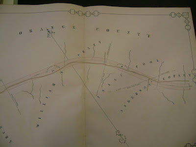
It's hard to live in Durham and not notice the train tracks and the trains, at-grade crossings, and occasional deafening horn blasts that come with them. Most people probably also know the basic facts about Durham being founded as a depot on the new North Carolina Railroad in the early 1850s - the railroad needing a water and fuel depot somewhere between Raleigh and Hillsborough and Dr. B.L. Durham willing to give up some land to the company. The story has been told a number of times but it's worth reading Jean Anderson's account or Gary's at Endangered Durham. What seems to circulate less widely are the railroad survey maps made when the course of the track from Goldsboro to Charlotte was being planned. By far the definitive account of all things NC RR related is Allen Trelease's The North Carolina Railroad, 1849-1871, and the Modernization of North Carolina which has good chapters on both its founding and the process of surveying and building it's length. Engineer John McRae was in charge of the part of the survey that went through today's Durham and his surveyor's and draftsmen as well as those of the other sections of the RR produced a set or really extraordinary small scale maps of every foot of planned track with local watercourses, buildings, and property lines. The original maps are held at the state archives in Raleigh and are fairly easy to request if you take a trip down there. The best high resolution image of any part of the Durham segment that I know of is in Jean Anderson's book and shows the planned Durham's station depot as well as a few scattered buildings in the immediate area.

I was in the Raleigh archives a few months ago and figured I should take some photos of all the maps which cover today's Durham. I was lazy however and after I stopped after a lot of odd looks from other archivists and other researchers for standing on a chair trying to get all of each map in one photo (the maps are really quite large). As a result the maps aren't as high resolution as they might be (though every word should be readable) and more importantly some of the edges are cut off - I haven't cropped them or prettied them up so you can see the full layout and where the edges should be. Nonetheless I've put together a tentative google earth overlay of the survey maps from downtown Durham to the west past Pinhook. I've done my best but since I missed small bits of the maps in photographing and because I took the pictures from an odd chair-standing sideways angle they aren't quite at perfect scale. Mostly I'm just making excuses for why I just couldn't get them to fit on today's map as seamlessly as I wanted. I've posted the three maps below with the four overlays linked underneath and you probably get the best effect if you have them all open at the same time (the Durham's station bit gets chopped in two for the overlay - don't ask).


Planned Durham's Station depot (overlay1, overlay2)


Pinhook area west of the station (overlay)


Hickstown - West Durham (overlay)

Besides establishing me as one of the worst archival photographers in the state, these maps help to show how much Durham grew within just a few decades (compare 1881 map here). Families like the Turners and the Hicks remained in Durham for the duration but property lines shifted with the growth of the town (Pratt's illegitmate children also remained important in Durham politics into the 20th century - more on that in future postings). J.R. Green, one of the creators and first marketers of Bull Durham tobacco bought (at least part of) Andrew Turner's farm before the civil war and William Pratt's land was split up after his death in 1867 (see post below). Pinhook ceased being the raucous site of naked whiskey racing by the late 19th century(I hear there is a new bar called Pinhook in the works for Durham that seems like it may live up to that legacy), more and more people and businesses business built on this ribbon of land around the NCRR, and by the creation of Durham county in 1881 the surveys above would have been unfamiliar to most newcomers.


Monday, September 1, 2008

First Durham Map

Before I can come up with another longish post I thought I'd go back to putting a few more general maps up. I've displayed two maps below. One of these two maps was the first general state map to include Durham. The North Carolina Railroad put Durham's station on the map remarkably soon after the first train service in the early summer of 1855:

From the NC Maps Collection at UNC (see links to the right)

This map (above) was published as part of an atlas between 1855 and 1860. It's fairly simple and doesn't depict many of the smaller towns and crossroads in the area - perhaps unfairly catapulting Durham into the minds of readers as it still had only a couple hundred people living in is vicinity. Also it seems that the Eno got lost in the shuffle of this map though it does include New Hope creek flowing south from the Durham area.


The map above has the potential to be the earliest of the two and was published in either 1858 or 1859 also as part of an atlas. I especially appreciate the added detail though I have to say that the measuring is a bit off as Durham has been shunted almost all the way to the Orange county line and quite far south of the Eno. I'd love to know if anyone else can find an earlier atlas or large scale map that depicts Durham